Nashville Battlefield Topographical Map Dating from 1864 – 65

Click to enlarge
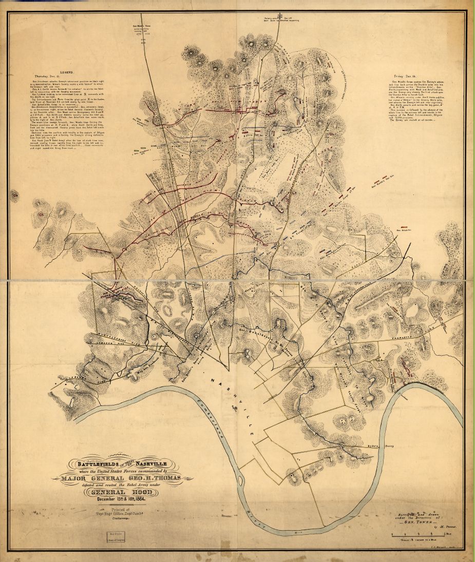
The excellent topographical map above is attributed to Col. William E. Merrill of the 1st U.S. V.V. Engineers, Chief Engineer for the Department of the Cumberland. It is one of the best detailed maps of the battlefield showing battlelines and key geographical sites on both days of the battle. The elevations are particularly helpful in interpreting the battlefield. (Map courtesy of and a thank you to Richard Melvin of North
Carolina.)
_________________________________________________________________
TSLA UNVEILS NEW HIGH-TECH INTERACTIVE CIVIL WAR MAP PROGRAM
The Tennessee State Library and Archives (TSLA) has announced a new on-line mapping program which depicts Civil War battle areas in various formats. The Tennessee Civil War Geographic Information System (GIS) Survey is the first of its kind in the nation. It shows hundreds of locations where Civil War battles, engagements, skirmishes and other military actions took place. The interactive GIS application for the Civil War in Tennessee is now available at the Library and Archives website.
The web site allows modern aerial photography, street maps and land use maps to be overlaid onto sites where Civil War actions occurred in Tennessee. It also links narrative information about these events from the Tennessee Civil War Sourcebook. Complete accounts of all the state units that served in the war are searchable by county along with 1860 United States Census data. The Tennessee Civil War Survey is funded by the American Battlefield Protection Program (ABPP) of the National Park Service.
________________________________________________________________
Below is a sampling of maps to help interpret the run-up to the Battle of Nashville and the battle itself, depicting Union and Confederate lines, areas of conflict, strategic action and terrain on both December 15 and 16, 1864

Above: Hood’s campaign moving from Georgia to Nashville, 1864 (Click to Enlarge)
 Map depicting both days of the Battle of Nashville (Click above map to enlarge)
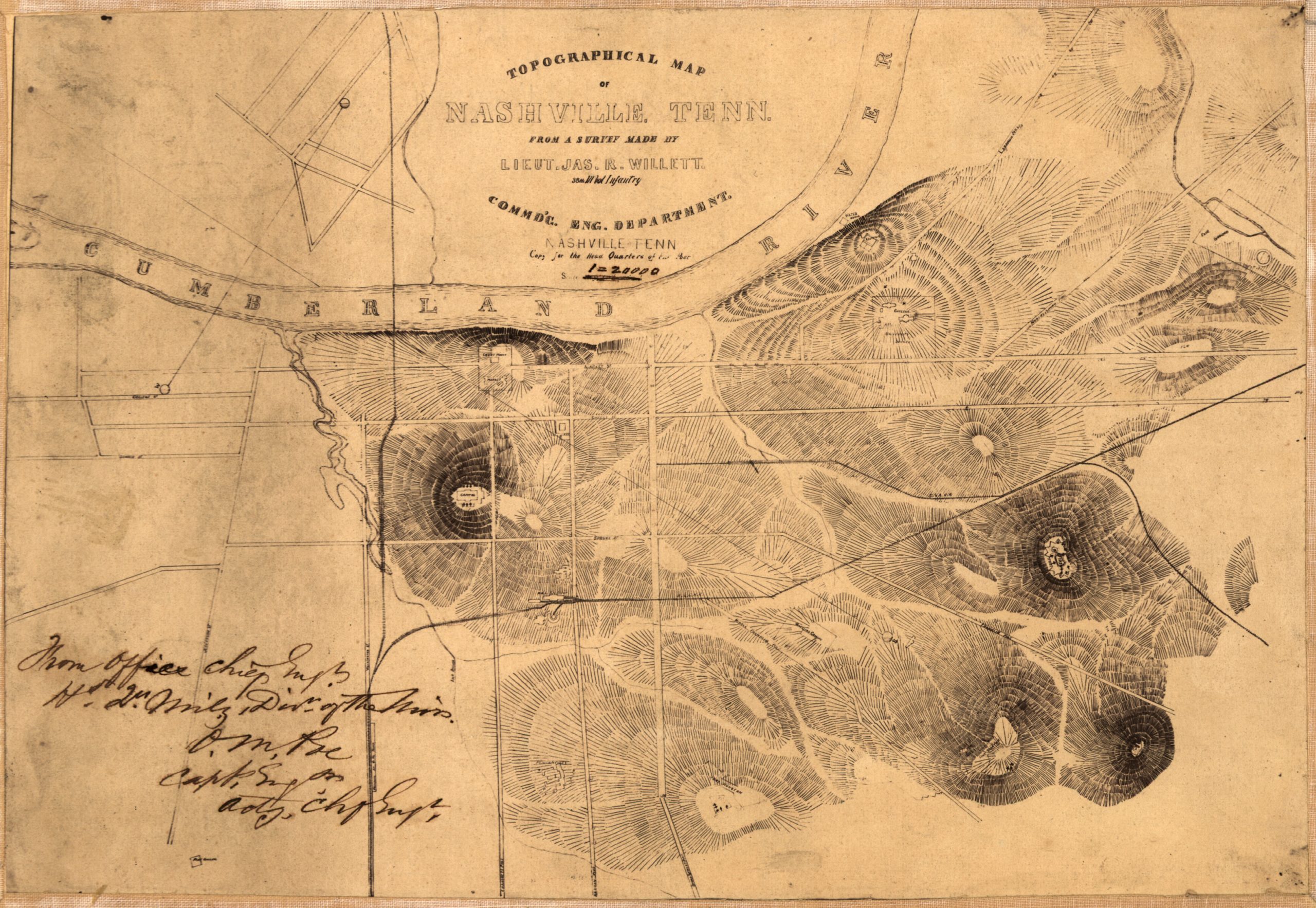 Above: Topographical map of Nashville drafted by a U.S. Army, Military Division of the Mississippi, Chief Engineers Office, showing major fortifications during Civil War Nashville. Map is oriented with north toward the upper left. Click to enlarge. For further information, click here.
Fort Brentwood

(Click to enlarge)
This is a copy of an original drawing by John L. Anderson of the Brentwood Stockade. It was probably drawn in 1863 and is on display courtesy of the Jim Kay Collection. The only other known sketch of the stockade was completed by Anson Smith is in The National Archives. Built during 1862 to guard the railroad bridge at the Little Harpeth River, Fort Brentwood housed troops from the 104th Illinois as well as the 19th Michigan. On March 25, 1863 the stockade was captured by the 4th Mississippi and the 10th Tennessee Calvary units under the command of General Nathan Bedford Forrest. Captain Elijah Bassett surrendered the garrison of the 19th Michigan, which included about 200 men, all supplies, arms, and a dozen wagons. Forrest retreated west towards Hillsboro Road where he was pursued by Brigadier General Green Clay Smith and 700 Union Calvary.
________________________________________________________
The John Overton Plantation
The PDF link below contains a map of the plantation owned by Judge John Overton (1766–1833). The house was originally constructed in 1799 by Judge Overton, who was a close friend of Andrew Jackson, co-founder of the city of Memphis, and one of the City of Nashville’s most historically prominent citizens. The plantation, covering more than 1,000 acres, was heavily involved in the Battle of Nashville. The Overton home (“Travellers Rest”) was used by Confederate Gen. John Bell Hood as his headquarters in December, 1864, and portions of the property were involved in the battle, including the significant confrontation on the Confederate right flank on December 16, 1864, known as Peach Orchard Hill. (Maps courtesy of Metro Archives, with special thanks also to Fletch Coke and Bertie Shriver).
Click link below to view maps: